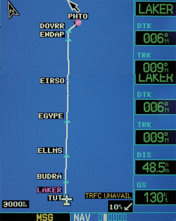
Parting
shot of the south Pacific island of Tutuila
|
I
was climbing on course for 110, and entered rain, sometimes quite hard.
It took quite a while to get to 110, and my ground speed was about 125
knots with 15, then 20, then 25 knots direct headwind. I used a lower
RPM for higher efficiency and saw I could make it, even at 130 knots with
a safe reserve. The miles did not vanish, though; it was painful slow
going, with the rain extending much further than I expected. I hoped to
be in the clear by sunset, and barely made it. It’s nice to see what you
are flying into. |
About
600 miles out, I had the EGT on #5 drop out, the engine was very rough.
I suspected a clogged injector, and was able to clear it by going full
rich and lean again. It happened a few more times, and I really began
to worry. I could fly with the engine running rough, but my range would
suffer dramatically. I asked San Francisco if they had surface vessel
information, but they could only provide information on the nearest emergency
field, on Canton Island. There were many obstacles, one that it was 281
miles away, but I made a waypoint and kept it on #2 GPS. Christmas Island
was the only field nearby, but it was 680 miles, and closed at night,
and Pago was about 700 behind me. Palmyra Atoll was on my path about 700
miles ahead. It has a 6000 foot private strip, but unlit. I was hoping
to make it till moonrise, which would greatly increase my chances of getting
down in just a few pieces, and I was all dressed up for a swim. The problem
would occur about every 45 minutes, but I was able to restore smooth power
by working the mixture. I also had concerns about the Pago fuel, and had
several tanks with fuel from New Cal and backwards. It kept happening,
but didn’t worsen. San Francisco was very helpful, and several other aircraft
checked in, particularly an Air New Zealand flight that checked into all
the alternates available. |
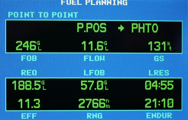
Fuel
planning information, the worst estimate of the trip |

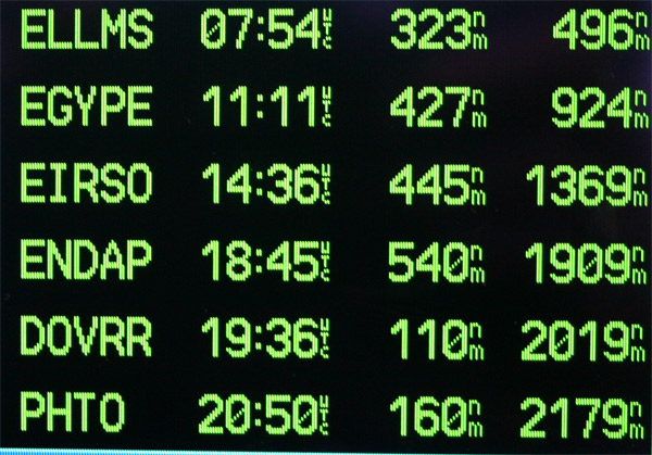
The
sun sets south of the equator three hours into the trip
|
I
toiled along at 125 to 130, looking at depressing ETAs, continually checking
the fuel, but never having less than a 5 hour reserve. Things improved,
and I flew by Palmyra, never seeing it under a cloud deck. Would have
been dark and nasty as an alternate. I’m ten hours into the flight with
six to go, and I get into the weather forming at 8 degrees north latitude,
and get into some hard rain and turbulence, and the engine starts running
rough again. It sort of dies when I put the mixture full rich, and this
is exciting, I also smell something like insulation. I have just about
finished the cabin tank transfer, and I hear a rattling, which is the
transfer pump failing. All this happens at once, but I don’t feel tired
any more. I turn off the pump, and check with the backup, the tank is
just about empty. I have a spare Facet pump, so at least I can be back
to two pumps without any part ordering. I have arranged for service in
Hilo, and my little list gets longer every hour. After an evening of crystal
clear HF communications, things get tough and none of the frequencies
is clear, but we manage, SF has been keeping a good watch on me. |
Finally,
the headwind abates and I see speeds of 150, then 160, and can increase
power some. I have a reserve of 60 odd gallons, or about 5 hours, projected
after 2250 miles. My final waypoints are on the moving map, and I look
over the approaches at Hilo. The sun is lighting up the sky to the east
as I am about three hours out, and I try to stay entertained and alert.
No engine troubles for about 2 hours, maybe I’ll make it in without any
more issues to deal with. I can’t wait to see Mona Loa and Mona Kea on
the horizon, but time moves at it’s normal pace. Added to that the headwinds
reappear, about 20 knots, but I can make about 150 knots. About 260 miles
out, I am cleared direct to Hilo, and asked to contact Honolulu on VHF.
|

I
pass the equator for the last time on the trip |

The
sun rises three hours from the end of the trip
|

Welcome
sight, the big island of Hawaii |
I
fly over the volcano area, and there is lots of smoke and “vog” with a
clearly visible plume. I get a visual to 26, and land. The weather
is clear and beautiful. I taxi to parking, and two really pleasant Customs
officials greet me. Some paperwork, they want to see the tank papers,
but I happen to have copies of the entire logs, with every 337, I have
my decal, I have my gen decs, and these guys are thrilled. We just talk
about the trip, and they leave me to go with a minimum of hassle. The
ground keeps moving, but it is the first familiar ground I’ve seen in
five weeks. I then taxi the plane over to the shop, and change the oil
and filter, the transfer pump, and look at one nasty injector. The Facet
pump that failed has some junk in it, so it seems I’ve gotten cumulative
contamination. Time for fuel system spring cleaning, before getting a
thousand miles from an airport again.
|

The
chain of craters runs down the slopes of Mona Loa |

A
plume of gas flows from the currently fairly active volcano |